Localisation and climate in Warsaw
#Warsaw tour guide #Warsaw city guide # guided tour in warsaw #Warszawa tour guide #Warszawa city guide #guided tour in Warszawa
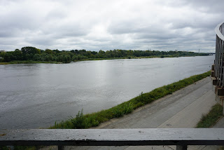
The Wisla river runs through Warsaw and split the town into two parts. In the old days, more water used to run through it than today, and the water level is often so low that it is impossible to sail with excursion boats. But in the old days, the river was the lifeblood of the city. Rafts with grain were transported down the river and subsequently shipped out from Gdansk. In modern times, the lowest recorded water depth is 62 cm, while the highest water level of about 8 meters was recorded in 2010, when the river was just a sandbag away from flooding the expressway that runs along its banks. Within the municipal boundary, the river runs for a length of 31 km, and it is possible to take a bicycle ride all the way along the river.
The city stretches out on both sides of the river – the left bank (west) is the area where the Old Town, the ministries and the parliament are located, while the right side (east) consists predominantly of the district of Praga . It is usually considered more “distinguished” to live on the left side than on the right side, but with the arrival of new bridges and in particular an efficient subway, this is slowly disappearing. If you want to remember what is right and left, you have to imagine that the river is alive. It runs through the whole of Poland and empties into the Baltic Sea. The way the water flows (i.e. towards the Baltic Sea or towards the north) is the head, and here we can easily ascertain what is right and what is left.

The Wisla River provides a great natural experience in many places
The left side is significantly higher than the right side. It also means that Warsaw’s Old Town is located on a salient, where a steep slope leads down to the river valley. On the right, a large part of the area down to the river is designated as a safety zone, where the water flows in when meltwater in early summer causes the river to rise. Here, the vegetation can generally develop wildly, and in the summer it is a splendid recreational area for nature connoisseurs.
But apart from the steep slopes down to the river, Warsaw is a relatively flat area, which is ideal for bicycles, scooters and roller skates… and for walking.
Warsaw is located in the middle of Poland, and as such the city is an ideal place if you want to get around and visit other parts of the country. The infrastructure upgrade that has taken place within the past 15 years has been centred on making Warsaw a hub, so that there are good connections, whether by plane, train, bus or car.
In terms of temperature, it is a continental climate. This means that the winters are generally somewhat colder than at the coast line, while the summers are somewhat warmer. The coldest I have personally experienced was around minus 24 degrees in 2006, while the summers can sometimes be very hot during the day. However, recent years have brought mild temperatures and limited snowfall in winter as well as ideally warm summers that haven’t felt like a sauna. Some people believe that this is to be attributed to global climate change. It rains a little more in the summer and a little less in the winter. It doesn’t rain that often, but then it often rains for prolonged periods when it does rain.
In addition to the vegetation on the floodplain, the city planners have provided plenty of parks. There is also a lot of forest, which is primarily located near the city borders. On the left is the largest forest, the Karbacki forrest (las kabacki), which is a recreational area. Larger and a bit wilder is the Sobieski Forest in Wawer on the right side (Rezerwat im. Króla Jana Sobieskiego), which is part of the area’s ancient primeval forest.
Please send an email to m@hardenfelt.pl if you would like an English-speaking tour guide to show you the most important places in Warsaw.
